Pages

Showing posts with label volcano. Show all posts

Wednesday, May 9, 2012

I'm Not Leaving Until I See That Damn Volcano

Volcano Santiaguito is one of the most active volcanoes in the world, burping out smoke and farting out gas every 20-40 minutes since 1922.

(Considering the state of my stomach in Guatemala, let's just say that I can empathize with Mother Earth's indigestion.)

Santiaguito is stuck to the southwest flank of Volcano Santa María, less than 10 km from Quetzaltenango/ Xela.  With a real, live volcano practically in our backyards, how could we leave town without seeing it?

There are two ways to see Santiaguito:  hike to an overlook/ mirador on the side of Santa María, or hike all the way to the top of Santa Maria.  Dave and I did both.

Hiking (Independently) to the Santiaguito Mirador

I put the (independently) in parentheses because you will probably get lost and might get robbed on this hike.  If that's intimidating, never fear--you can always hike with Quetzaltrekkers!

Dave and I did this hike with a few people we met through QT.  We did get lost, a bunch of times, though we didn't get robbed.  Along the way, Dave was smart enough to take some photos for trail notes to share with other independent hikers.

First, take a bus from the Iglesia El Calvario near the cementerio to the village of Llanos del Pinal, at the end of the line.  You might have to get on a bus headed into the city of Xela, toward Minerva terminal, because it seems like sometimes the buses take different routes into and out of the city.

When you get off the bus, continue up the main road in the village, toward Santa María.  At the end of the village, the road will appear to turn right--you want to continue straight, up a drainage, through agricultural fields.
go straight here, into the fields
Follow the drainage as it gently ascends, always aiming for the cone of Santa María.  After a while, you'll pass some "spiky trees."  There will be a few paths branching off to the left--these go to Santa María.  Stay straight.
spiky trees: go straight on
Within a few minutes after the spiky trees, as you pass a wooden fence on the right, the path will split.  Take the right junction.  Based on the contours of the land, it almost feels like you're going straight.  This is the only real junction on the entire hike.
wooden fence: go right, which sort of feels like going straight
From this point, you are no longer traveling directly toward the cone of Santa María, but rather traversing across her flank, always gaining altitude slowly.  Continue on the path, which will become a dirt road for a while.  When the dirt road opens into a grassy area, again continue straight through.
dirt road to grassy area: continue straight through
After this section, the trail gets overgrown and messy.  If it gets too crazy, though, consider whether you're still on the main trail.  You shouldn't feel like you're bushwhacking into a jungle.  Always follow the major herd paths.  At a few points, you'll need to cross makeshift fences of sticks.  Please don't disturb the fences, as they keep livestock in place.  We had to cross two makeshift fences, and I get the impression these fences are put up and taken down regularly.

By the time we got to the mirador (after several wrong turns and some crazy bushwhacking--remember, if it seems like you've taken a wrong turn, you have), the clouds had rolled in and there was no volcano to be seen.  We did hear it, though, rumbling like distant thunder.
no views. wahh.
Try again next time.


Climbing Volcano Santa María

In order to beat the clouds that roll in most mornings during the rainy season, we had to be up, literally and figuratively, early in the morning.  And what better way to be up and up than to climb Volcano Santa María under the light of the full moon and greeting the dawn from her summit!  We signed up for our hat-trick third hike with Quetzaltrekkers, the Santa María Full Moon hike.

The hike itself wasn't that hard.  We piled into the back of a delivery truck for the drive to the Llanos del Pinal trailhead and started hiking at 11:58 p.m.  The only less-than-agreeable part of the hike was a 45 minute break after only an hour of hiking to wait for a lone straggler, way behind the pack.  I wish the whole group didn't have to wait, because she ended up turning around at this point and we were all super cold and tired by the time we started hiking again.  Nonetheless, we had a pretty strong group and the first of us reached the summit by 3:40 a.m.  By 4:00 I was fast asleep in my sleeping bag.
zzz
Dawn brought us a decent but not spectacular sunrise.  It's always hazy and cloudy here, definitely not a great place for views.
snuggled in the sleeping bag--it's cold at 12,375 feet
But fortunately, we were able to look down directly over Santiaguito!  And we got to see two fantastic, loud, dramatic eruptions!
KA-BOOM!!! grumble rumble smash
As we turned our backs on the summit and started our descent, Dave commented that every step we took would bring us closer to home.  I liked that thought.  It reminded me of the moment during the roadtrip out West in 2011 when I turned around in California and, for the first time in a long time, started traveling east instead of west.  That time, I knew I wasn't ready to be home.

This time, I think I am.
from this point forward, every step brings us closer to home :-)

Sunday, April 22, 2012

And Finally, Guatemala

From Copán, it was a (relatively) fast, (relatively) comfortable, (relatively) cheap shuttle across the Guatemalan border to Antigua...

to meet Dave!  YAY!  Central America just got that much cooler.  And I'm never running off without this dude ever again.  :-)

yayyy
Right on cue, I got sick.  It started with stomach cramps and fatigue and quickly progressed to cascading waterfalls.  Bummer.  I started an antibiotic right away, and by the following day was feeling better.  This time I think it was from untreated water.  I got lazy and drank the "pure" drinking water at our guesthouse.  When in doubt: treat it.
ughhh
Alternating between the happy and the sick, Dave and I had time to wander around Antigua, climb part of Volcán Pacaya, and move our base of operations over to Quetzaltenango.

Antigua wasn't really my style--I called it "A Nice Town If Gringos U Admire" in my journal.  There are some great restaurants and nightclubs filled with English speakers, but I don't enjoy either.  There is a ton of petty tourist crime, which I don't enjoy either.  And there is very little street life--for example, Dave and I found only one woman selling tamales near Merced and one woman selling tostados in the central market.
couldn't find tostados, but did find the statues from semana santa
One morning, we hiked up Volcán Pacaya.  Pacaya had an eruption back in 2010, and we were hoping to see some lava, but unfortunately the guides are no longer allowed to take tourists into the volcanic zone.  We had to content ourselves with climbing into a break in a lava tube (cooled lava, of course!).  Natural sauna!
dave gets roasted
We decided to get the heck out of Antigua and head for Quetzaltenango, aka "Xela."  Already I am liking it SO MUCH MORE than Antigua, because it feels like a functional city.  Even in the very heart of the old city, there are people who live, work, and play.  There is an ex-pat, gringo, and Spanish student presence, but it is secondary to the primary day-to-day workings of the urban fabric.  All the "good stuff" goes with that--people are friendlier, street food is abundant, and the markets sell bananas and colanders instead of keychains and postcards.
just some ladies out with their kiddo
Just for kicks, we decided to take a bus to a smaller mountain town called Zunil.  There is really nothing of note there, but I liked it.  We visited the little church, walked up some of the hilly streets, got a relaxed lunch in a cafetín, and stumbled upon the entire village getting ready for the next day's market (I have never seen such huge bags of enormous carrots).
Zunil's central plaza, with church and chicken bus
From here, Dave and I will be out-of-communication from Tuesday, April 24 through Sunday, April 29.  We are headed up to Nebaj to hike to Todos Santos with a group called Quetzaltrekkers.  I am really looking forward to getting out of the city and hiking.  I will definitely post photos and updates when we get back!

Thursday, July 22, 2010

The Easiest Mountain I've Ever Climbed

Mt. Bromo:  hands down, the easiest mountain I've ever climbed.

Dave and I were planning our next move, and we realized that booking a package tour from Yogyakarta to Denpasar in Bali, with a stop in Bromo-Tengger-Semeru National Park, would be nearly as cheap as going independently.  Sigh.  So, we joined the tourist herd for 48 hours.  In retrospect, even though the mini-bus was cramped and the air-conditioning didn't work and the whole shebang was incredibly disorganized, it was probably better than the multiply public transport buses, mini-buses, and bemos we'd have to take.

We got up at 3:30 a.m. to catch a jeep up Mt. Penanjakan to see the sun rise from the north of the volcanoes.  The sunrise wasn't anything amazing, but holy guacamole, those are some pretty pretty mountains!!!

almost like looking at a painting

We piled back in the jeep and headed down into the "Sea of Sands," the inside of the massive crater from which rise the three volcanoes in the foreground above (Semeru, the tall mountain in the back, is outside the crater, to the south).


So, this is how I climbed the easiest mountain ever.  The jeep drops you off about 1-2 km from the mountain itself.  You walk across the sand, avoid the local Tengger people selling bottled water and horserides at the base of the mountain, then climb 253 steps to the top.  Yeah, there's a staircase.  But the crater at the top is pretty sweet!

holy smokes...  literally!

Here are the rest of the pictures from the day:


Here's what I'd do differently, if I visit again:

Sunday, April 25, 2010

Taranaki: This Makes 3 Mountains in 5 Days

Back in New Plymouth at the library.  Two days ago, after sitting right here, we went to the North Egmont Visitors' Center, packed our bags, parked the van, and hiked in to the Maketawa Hut.  The New Zealand Department of Conservation maintains hundreds of backcountry huts, which are very convenient for hikers and trampers.  This was my first night in a DOC hut with my brand new, shiny backcountry hut pass.

thumbs up!  DOC hut!

At first, I wasn't sure if we'd get to climb Taranaki, due to the clouds covering the mountain.  But when we woke up in the morning, the summit was clear, so we decided to give it a try.

whoa...  that shit is STEEP

First the track takes you up a steep road to an alpine club hut.  Then it climbs through a little gorge to a series of stairs.  From the stairs, you drop out onto the scoria slopes (steep slopes covered in gravel and sand).  Last, you climb a steep, old lava flow nicknamed "The Lizard" in a long scramble to the top.  At the top, you cross an ice- and snow-covered crater to get to the true summit.  Except we didn't stand on the true summit, as it has religious significance for the Maori.

above the clouds :-)

After getting my butt handed to me by Ruapeho, I was so happy that this day went well.  The climb is steep and strenuous, but it's definitely "do-able" by mere mortals, like myself.  The hike rises 1.6 km--one vertical mile--in about 5 km (~3 miles).  I've now climbed the three major peaks on the North Island in the span of five days.

Here are the rest of the pictures from the day:


We're going to head toward Wellington later today, then on to the South Island and all of the wonderful hiking and tramping there!  I've written a few posts to automatically post over the next week or two, but maybe we'll find another public library soon.  Until then...  onwards and upwards!

Friday, April 23, 2010

Tongariro II: Who Goes To Mordor Twice?

At the moment, Dave and I are in New Plymouth, a lovely little city on the Pacific Coast near Egmont National Park and Mt. Taranaki.  We jumped into the public library to use the internet.  Here's a recap of the past few days...

About a month ago, I took an “epic” trip to Tongariro National Park with my Earthwise Valley friends (read about it here, here, here, and here).  We climbed Ngauruhoe, the conical volcano (~2200 m) that was the inspiration for Mr. Doom in Peter Jackson's the Lord of the Rings movie trilogy, and part of the group climbed Ruapeho (~2700 m).  I didn't get to climb Ruapeho, and Dave didn't get to go on the trip at all, so Tongariro was the first stop on our New Zealand road trip.


Day 1, Tuesday, 4/20:  We had left Tuateawa late the previous day, so we woke up early and finished the drive to Tongariro.  After prepping our packs, we hit the trail around 11 a.m.  We took our time and enjoyed the great weather as we passed Taranaki Falls and then the Tama Lakes.


We got to the same basecamp where I had camped four weeks previous in the late afternoon.  There was plenty of time to scout out a flat tent site, sheltered from the wind, to set up the tent and sort gear, to dig a latrine hole, and to put together dinner fixins'.


The sunset wasn't as spectacular as the first sunset the last time I was there, but it was still very pretty.  Since we had arrived at the campsite so early, we were in the tent only an hour after dark (7:30 p.m.).  We stayed up talking until about 9:30 p.m, until we were able to doze off.  It was a cold and windy night.


Day 2, Wednesday, 4/21:  Summit day!

Thursday, April 1, 2010

Tongariro: Part II

Day 3:  Summit day.  We got up relatively late, packed our day packs, and set out.  Ngauruhoe is basically a huge pile of large rocks, small rocks, gravel, pebbles, and dust.  The beginning part of the climb was pretty enjoyable.


Later parts of the climb were more strenuous.  The gravel was so soft and footing so unstable that sometimes it was literally "one step forward, slide one step back."  I let my Jersey upbringing shine through with more curse words than I think I've said in the past month.  We took plenty of breaks, and I found the climbing to be tough, but not too bad.


And holy guacamole, were we rewarded with a view!

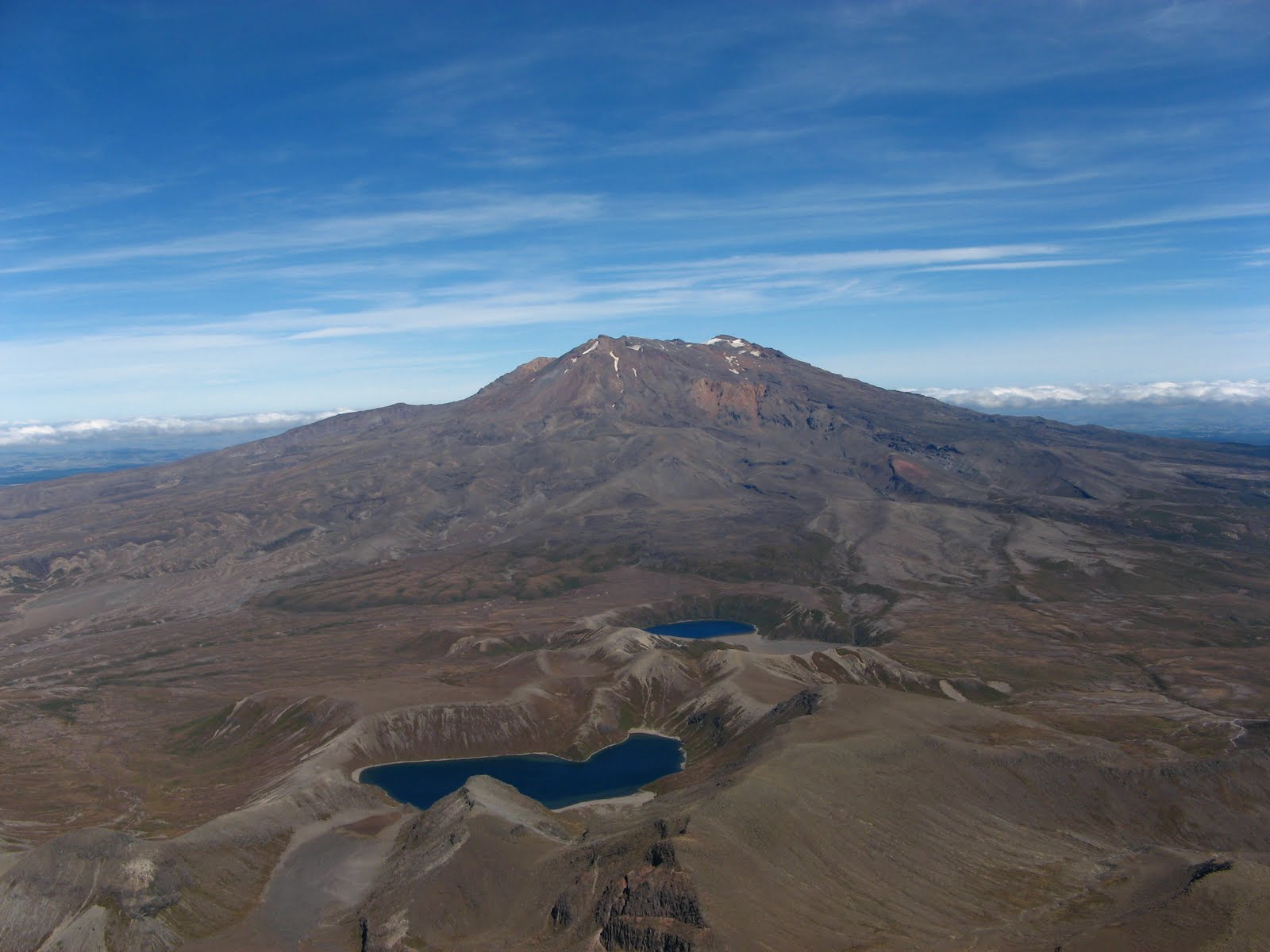
Mt. Ruapehu, with the Upper and Lower Tama Lakes in the foreground.  View from the rim of the outer crater of Ngauruhoe.

After climbing to the rim of the crater, we actually climbed down into the crater to see what we could see.  In one place, we found a geothermal vent spewing steam into the cold, dry, windy alpine air.  We could see John, from our party, over on the other side of the outer rim (that's him, the little black speck, in the picture below).


Finally we got to the grand finale:  the inner crater.  The Fires of Mordor, if you're a fan of the Lord of the Rings movies.  So here I am, looking way too freaking happy.  I must have stolen The Ring or something.


On the way out of the crater, I made sure I hit the true summit.  Proof:


You can't imagine how windy it was as I was taking that picture.  I nearly had Pippi Longstocking braids, sticking straight out from my head!

The hike down was more slide than hike.  I managed a significant portion of the descent on my behind to keep my center of gravity low and to protect my knees as best I could.  I didn't find the climb or the descent too bad, which was reassuring, since I haven't done much hiking or climbing lately.  When I got back to our base camp, I realized that the mountain had left her mark on both my pants and Laura's pants:


It's gonna suck to sew that up.

Some of our party had a pretty rough trip up and down the mountain, so we played some Yahtzee in our tent to pass the time until bed and to cheer everyone up.  It was a lot of fun.  And that was summit day.


P.S.  One more mountain to go!

Wednesday, March 31, 2010

Tongariro: Part I

Last week, we went on an "epic" trip to Tongariro National Park in order to hike/ climb volcanoes.  Tongariro is an awesome place.  The alpine landscape feels pretty desolate, like you're wandering around another planet.  Tongariro is the oldest national park in New Zealand, the fourth oldest national park in the world, and a dual UNESCO site for both its cultural and natural heritage.  This is a quick trip report.

Day 1:  It took a while to get ourselves together in the van to leave Tuateawa.  On the way, we stopped in Thames for some errands, then continued the drive down to the middle of the North Island.  We hastily make camp at 11:00 p.m.

Day 2:  We hastily break camp in the morning when a ranger kindly alerted us to the actual location of the campsite.  We parked the van at Whakapapa Village and set off into the park toward Taranaki Falls.


The first portion of the hike was pretty easy and relatively flat.  Very enjoyable.


We had awesome views of Ngauruhoe the entire time.  Here she is, next to the Upper Tama Lake.


The second portion of the hike was a little more tiring, as we had to climb a long ridge, then traverse it while the wind was whipping around us.  Unfortunately, we then had to descend the ridge, then climb another to get to our campsite right at the base of the mountain.


The campsite was pretty sweet.  The views were great, although it was extremely windy.  I probably wouldn't camp there again; instead, I'd choose a more sheltered spot.  Regardless, I'm not going to include a map of our approach, our campsite, or our ascent line.  Right now, most hikers on the Tongariro Crossing take a completely different approach, and we'd like to keep it that way!

In the evening, I experienced the most amazing sunset I've ever seen in my entire life.  We were above the clouds...  could see Mt. Taranaki peeking through, in the distance...  the colors were otherworldly.  Nothing beats this...


...except this:  while watching the sun set in the west, I turned around and saw the nearly full moon rising over Ngauruhoe.  


This world is one great dewdrop, indeed.


P.S.  Summit day(s) and more coming up later.  Stay tuned!