Pages

Showing posts with label nevada. Show all posts

Sunday, June 8, 2014

Trip Report: Mt. Tallac via Gilmore Lake in the Desolation Wilderness

(Writing this blog post on 6/21 about a trip that happened two weeks ago...  better late than never!)

Continuing west, we decided to swing by Lake Tahoe on a whim after a suggestion from our SLC hosts.  Sunset from the eastern shore of the lake was beautiful.


The not-so-glamorous parts of life in The Matrix:  the mosquitoes were so bad that they were landing on, and attempting to bite, our dinner sausages (gross).  You can only imagine what they were doing to us!
cooking dinner at spooner summit in serious clouds of mosquitoes
 At this point, we had been on the road for a week, and we hadn't really "done" anything except drive.  I was itching to get away from cars, roads, and people.

We decided on a simple overnight trip from Fallen Leaf Lake/ Glen Alpine trailhead (6,540') up to Gilmore Lake (8,350'), then on to Mt. Tallac (9,500').  More time to acclimatize and another chance to test my DIY gear before my Yosemite solo.

relief map of our trip
The hike up the Glen Alpine trail was really beautiful.  I enjoyed the wildflowers, giant trees, and the moderate trail.  There was one very confusing trail junction (see beta below), but otherwise, the walk was pretty easy.


The shady shores of Gilmore Lake still had some snow piles in early June.  Not a lot, but enough for a snowball or three!

incoming! duck!
After making camp, we started up the trail toward Mt. Tallac.  Very soon we found ourselves WAY OFF TRAIL and bushwhacking up the mountain.  From the cairns and occasional bootprints, it was clear that we weren't the first to make this mistake.

bushwhacking :-/
By following the contour lines on the map, we were able to meet up with the summit trail.  A little rocky scrambling, and we were at the top!

looking toward the california sierra - one of those "once in a lifetime" shots - butterfly flies through the frame!
awesome views of lake tahoe (left) and fallen leaf lake (right)
gilmore lake, where we camped, in the distance
The weather was perfect for relaxing on the summit.  After so many miserable Adirondack summits, I can see why Californians like their weather!

Back at camp...
tarptent for dave; hammock with net for me
...the mosquitoes were swarming SO THICKLY it was impossible to leave any skin uncovered.  I was told that the mozzies do this for a few weeks each year, and we managed to arrive right in the middle of their annual block party.
fully covered and still hiding in the tent
dawn from the hammock. safe from the mosquitoes!
On the return walk to the trailhead, mosquitoes were biting through my long-sleeved shirt while I was walking.  Pretty intense...  but the wildflowers were still so pretty!

more wildflowers
I would recommend this trip as an easy-moderate overnight to escape the Lake Tahoe crowds.  But!  You should take some trail beta with you, because there were a few times that Dave and I found ourselves mighty confused, even with a map and compass.

Trail Beta

First, shortly after you pass the old Glen Alpine camp, you will see what appears to be a trail junction marker.  Just kidding!  It's not.  Both arrows for Susie Lake AND Grass Lake are pointing in the same direction - up the trail.  Keep going and don't bear right (north).

lies
Second, there is a tricky turn on the established trail from Gilmore Lake to Mt. Tallac.  As you walk up the gentle slope leading away from the lake, you will pass a large downed tree before coming upon the first rocky slide.
pay attention for this tree!
It appears that the main trail goes left - but you want to go RIGHT, where you see Dave standing in that photo.  Continue for a few seconds to the base of the rocky hillside, and BEAR RIGHT again, a >90 degree turn right around the trees shown in this photo.  You will ascend the hillside on the right side of the rocks, looking for cairns before finding a herd path.
go right, again, around the trees in the center of the photo
It seems that folks who go off-trail traverse farther and lower down around the lake, then climb the col on the western side of the mountain, then traverse again around to the bottom.  The established (shorter) trail takes a more gentle climb up toward Mt. Tallac, veering away from the lake earlier and not heading directly toward the col.

Hope that helps!

Tuesday, March 29, 2011

Eastbound, At Last

For the first time in well over a year, I'm headed eastbound instead of westbound. Moving westbound last year, west and farther west still, brought me around the globe—and then I continued west, again, this year.

Always chasing the setting sun, I've occasionally wondered if my perpetual westward heading related to some conclusion in the broader context of my life. Cutting myself free closed one chapter. This year I'll turn 29, completing my 30th year on this planet. As I turn eastbound, toward the rising sun, I can't help but think about beginnings, about joyfully opening a new chapter, and about everything I can look forward to.  :-)
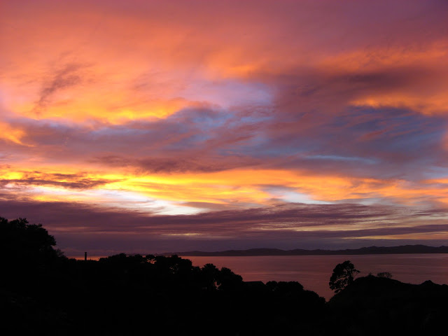
sunrise over tuateawa bay, new zealand

Anyway! What's happened since I've turned eastbound? Seems like my priority has been adventuring, rather than writing about adventures. Some day I'll write more about my time out West. But, for now, here's a quick update, starting from California.

San Francisco: I rejoined Davo, and we went to Muir Woods so he could see the Redwood trees. John Muir is quite an inspiration to me (this blog is named for one of his quotations). The place was crammed with people, even though it was raining, so it wasn't really a place for quiet contemplation and reflection.

golden gate bridge, after the rain

That evening, we hung out with Jenny O, an awesome woman we know from Ithaca. The weather sucked, so we decided to move on to...

Yosemite and Sequoia National Parks: which we did not get to visit. Still snowed in, tire chains required. We continued on to...

Death Valley National Park: In the hottest, driest place in North America, I experienced the worst, coldest, wettest, nastiest weather of the road trip when a freak storm blew through. There was tons of rockfall across Towne Pass; we checked in with four cars disabled on the side of the road in poor visibility with rocks still falling around them as it snowed. So that's why they call it Death Valley!

"colorful"--for the desert--salt creek, home of the salt creek pupfish

Death Valley was more interesting than I expected, because of all of the organisms that have evolved to survive in this environment. Life will find a way! It was also more photogenic than I expected, with colorful badlands next to pure white salt flats under a blue desert sky.

Red Rocks National Conservation Area: Red Rocks NCA is ten miles in distance and a million miles in feeling from the Las Vegas strip. We did a half-day hike up Turtlehead Peak.

And, of course, we climbed! It was my first experience on desert sandstone, and I enjoyed the awesome weather, amazing scenery, super sticky rock, and very chilled out vibe. (Not going to lie, it was a nice, undeserved ego boost to climb about two grades harder than I do on the East Coast.)

red rocks panorama

The BLM campsite was totally full, but we found some guys from Colorado who had room for an extra car. Put a bunch of strangers around a campfire and you'd be surprised what wisdom results. I loved Red Rocks, and I would definitely return some day.

Grand Canyon National Park: Moving on to the Grand Canyon, I had no idea what we'd do. The weather wasn't great—overcast and spitting snow—so my first impressions of the canyon weren't, well, very impressive. Plus, backcountry camping permits book out months in advance.

Yet somehow our lack of planning and total flexibility snagged us a permit for Indian Garden! We hung out on the rim for a day and camped outside the park in Kaibab National Forest. The next day, we hiked 5,000 vertical feet down the canyon (via South Kaibab Trail), took lunch on the Colorado River, and hiked back up the canyon 2,000 vertical feet (via Bright Angel Trail). The next morning, we hiked out the remaining 3,000 vertical feet, in sunshine for the first time.

with the colorado river below us

Everyone talks about the Grand Canyon like it's the most amazing place on earth. I thought it was really impressive, but something about the hordes of people and the overly-maintained trails kept me from connecting with the Canyon. It is much more of a tourist attraction than a wilderness experience, which is fine—just not my cup of tea.

For personal and family reasons, I assumed that our southwestern adventures would probably end here. But a sweet turn of events meant that we continued to southern Utah... and that deserves a post of its own!