Pages

Showing posts with label nz roadtrip. Show all posts

Wednesday, May 26, 2010

Road Trip... Trivia!

The epic New Zealand road trip of 2010 has come to an end.  On Tuesday morning, I arrived back in Tuateawa, where I will be working and living for the next month.

The road trip was an awesome experience.  I could probably write a novel about it, but isn't a list of trivia more entertaining?  Yeah, that's what I thought.

Life in the Van Trivia
  • Road trip length:  36 days/ 35 nights
  • Distance driven:  5,447 km/ 3,404 miles
  • Nights in random people's houses:  2
  • Nights the cold kept me awake:  1 (thank you, upstate ny)
  • Total restaurant meals eaten:  3
  • Cheese consumed by both of us:  5 kg/ 11 lbs (eww)
  • Juice drank by Dave:  15 L/ 4 gallons
  • Diet cola drank by Nicole:  not telling you
  • What I think of oatmeal for breakfast:  like eating plaster
  • Longest consecutive days w/o seeing the inside of a shower or bathtub:  14
  • National Parks visited:  7 (Tongariro, Egmont, Westland, Mt. Aspiring, Fiordland, Mt. Cook, Nelson Lakes)
  • HEY COW points:  a lot
  • Favorite North Island city:  New Plymouth
  • Favorite South Island city:  Dunedin
  • Favorite moment:  hiking into Angelus Lake basin at sunset
  • Creepiest moment:  sharing a very small backcountry hut with an insane hunter packing a large rifle
Tramping (Hiking) Trivia
  • Distance hiked:  290.5 km/ 181.6 mi
  • Days hiked:  24 out of 36 (66.6%)
  • Trail hours:  113.5 (nearly three 40-hour work weeks)
  • Average trail speed:  1.6 mph
  • Approximate elevation gain:  8370 m/ 27,600 ft (almost an Everest)
  • Highest elevation:  2590 m/ 8547 feet (summit of Ruapehu)
  • Lowest elevation:  sea level (Tasman Sea)
  • Longest day:  10 hrs (camp to summit of Ngauruhoe to camp to Whakapapa Village)
  • Greatest consecutive days on the trail:  9 (Mt. Aspiring Nat'l Park to Routeburn/Caples Tracks to Kepler Track)
  • Longest without resupply:  5 (Routeburn/Caples Tracks)
  • Nights in backcountry huts:  11
  • Nights in a tent:  1
  • Named mountains summited:  5  (Ngauruhoe, Ruapehu, Taranaki, Luxmore, Roberts)
  • Alpine crossings:  8
  • Unbridged streams crossed:  38 (yes I counted)
  • Places where my boots are held together with glue:  11
  • Wipe-outs (defined as ass on ground):  9
  • Foot mishaps:  2 (1 strange something between the toes; 1 ball of foot strain)
  • Ibuprophen taken:  too many...  waaaaaaay too many
  • Useless DoC warnings:  3 (1 bridge out, but the stream was easy to cross; 1 hill slide that was easy to bypass; 1 very muddy section, which was actually dry)
  • Times I got rained on:  3 (not bad!)
  • Things I daydreamed about most while hiking:  a hot shower, obscene quantities of bacon (yeah, I know) and eggs, Mumford & Sons songs
  • Kea seen:  5
  • Sea lions seen:  3
  • Penguins seen:  17 (7 yellow-eyed penguins; 10 blue penguins)

The end...  or maybe to be continued.  :-)

Thursday, May 20, 2010

My Favorite Hike

Our last hike on this road trip was a four day excursion in Nelson Lakes.  Talk about ending with a "bang"--it was my favorite hike from the entire road trip, Great Walks included.

Day 1:  We got a late start from St. Arnaud, not leaving the carpark until after noon.  The first section, the "Pinchgut Track," was about an hour of switchbacks straight up the ridge.  More like the "Knee Cruncher Track."  We then took the Robert Ridge track...  felt like we were walking on top of the world.  There were sections that had very steep, long drops on either end, and we were working our way over somewhat unstable, uneven rock piles, but I did ok.  The sun had just dropped behind the mountains when we arrived at the final descent to Angelus Hut.  It was the single most beautiful moment of the entire road trip.  Pure magic.  Angelus Hut had just been rebuilt and reopened the month before, so it was new and very nice.

Day 2:  Long day.  We started down from Angelus Hut around 9:00 a.m. on the Cascade Track.  The first section of the track went pretty much straight down the back of the ridge.  It was slow going, especially due to my knees.  It leveled out a bit eventually, but we still had many hours walk through the beech forest.  Basically, we had to walk all the way around the big mountains.  Would have been much easier to go straight over!  We got to Hopeless Hut around dusk (5:30 p.m.).  Hopeless was an apt name.  We shared the six bunk, single room hut with a very creepy hunter.  I'm very glad I wasn't staying there alone with him.

Day 3:  Fortunately, Mr. Creepy Crazy Hunter got up before light to head into the bush, so Dave and I were able to relax with a cup of tea in the morning before hitting the trail.  We backtracked part of our steps from the previous day, following the Travers Valley.  We were only on the trail for about a half-day, arriving at Coldwater Hut in time for a late lunch.  We found two more hunters at Coldwater Hut, but they were completely different from Mr. Creepy Crazy.  The four of us had a raging fire going, and spent most of the evening talking about everything from guns to movies.  They were great company and great conversation.

Day 4:  After breakfast, we hit the trail for the last time.  We were only about 2.5 hours walk from the carpark.  The first part of the trail was more of the same (beech forest next to a body of water).  The very last part followed a gravel road, which was monotonous and boring, but it's always great to see the van after some time in the woods (and even better when the engine starts!).

The trip was great.  Arriving at Angelus at sunset...  the interesting trail down Cascade Track...  great company with the hunters at Coldwater...  definitely my favorite hike.

Check out the pictures.  The ones from the first day are stunning.  It was even better in person!

Saturday, May 15, 2010

Milford Sound, Mt. Cook, & OMG PENGUINS

Yeah, so, we went out to Milford Sound.  It looked just like the postcards.  It's a pretty fiord, yeah, but I have this feeling that it's popular because the tourism industry has made it popular.  We didn't do any of the cruises or anything like that.  Maybe if we had, I would have been more impressed.

looks like a postcard

Kea, however, will always delight me.

who is playing with whom?

We also went to Mt. Cook for a day.  That wasn't that exciting, either; the weather sucked, so I didn't even see the famous mountain.  Unless you're prepared with crampons and an ice axe, there isn't a tremendous amount of hiking to be done in Aoraki Mt. Cook National Park, either.

iceberg. kinda cool, but probably not worth the drive.

On the drive from Milford Sound to Mt. Cook, we stopped in Dunedin and the Otago Peninsula.  Dunedin was a sweet little city; it's definitely my favorite city on the South Island!  I wanted to visit penguin colonies on the Otago Peninsula.  The iSite tourist information bureau told us there was a chance that we might see penguins at a certain beach.  We went to that beach and got talking to a few friendly, kind Kiwis who told us that we'd have much better luck at a different beach.  Puttered down the potholed, one-lane country road, pulled into the carpark, ran down the largest sand dune I've ever seen, and HOLY SMOKES that's a BIG and unexpected mammal!

i think that i could outrun him if i needed to

We did make it to the hide while the yellow-eyed penguins were coming back to land from fishing at sea all day.  I was totally stoked, because yellow-eyed penguins are some of the rarest penguins in the world.

OMG penguins!!!

Here are the rest of the photos, with commentary:

Wednesday, May 12, 2010

This Is How I Earn My Trail Legs

We just finished nine consecutive days on the trail. It would have been ten, had we not combined the last two days of the Kepler Track. I don't have my track register handy, but I think that's about 70-odd miles of trail.

Last night we got takeaway dinner instead of cooking for the second time since we've been on the road. We stayed in a holiday park, complete with showers, laundry facilities, and internet access. I took a shower last night, and I'm going to take another one today before we leave.

 From here, we're heading out to the Milford Sound for a day of relaxation. From there, we'll make our way over to Mt. Cook National Park, then start working our way up the east coast of the South Island. We've been on the road nearly a month, and we'll be back in Tuateawa in two short weeks. Time goes so quickly.

So, yes, we got our multi-day backpacking trips. Two of them, actually, and we did them consecutively. It hurt, it was beautiful, and I'll never forget it. From here, I want to go see some cute, chubby penguins and climb a few more mountains. Don't worry about me, Mummers. That's the update!

Sunday, May 9, 2010

Kepler Track

We finished the Routeburn/ Caples on Sunday morning, making it back to our van in time for lunch.  We ate, unpacked, and went back to Queenstown and the DoC office to check the weather to plan for our next adventure.  What's that?  Another break in the weather?  If we left the very next day, we could start the Kepler Track outside Te Anau, and we'd have good weather for the climbing day and the alpine traverse day!  Were we crazy enough to start another four day trip, after six consecutive days on the trail?

That's a stupid question.  Of course.

Here were the highlights of the Kepler Track:
  • Dave's turn to get sick.  He got it worse than I did.  He's still sniffling.
  • The alpine section of the Kepler wasn't as magnificent scenery-wise as the Routeburn, but I liked it even more.  Instead of traversing the ridge on the slopes, you spend a lot of time walking across the tops.  You get to see both sides and feel a bit of the exposure.  
  • The second night, we enjoyed really nice evening conversation with the other folks staying in the hut.  It was all young people:  Canadians, Germans, Aussies, a Brit, a Kiwi, and us Yanks.
  • We ended up doing the Kepler in three days.  The last day, it was supposed to rain and I hadn't washed up at all after nine consecutive trail days.  I was ready to be out of the woods.  We were going to combine the last two days (17 km x 2 = 34 km, or >21 miles), which was completely do-able, as it was through a flat river valley.
  • In the end, our last day was about 25 km/ 15 miles.  We came out at a different trailhead and hitchhiked back to the start.  Dave ended up getting a ride with some of the Germans that had been in the huts with us.  He picked up the van and then came to get me.
Here are my favorite pictures:

Monday, May 3, 2010

Routeburn/ Caples Tracks

After our long day in Mt. Aspiring National Park, we went to the Department of Conservation (DoC) office to check the weather, which would inform our hiking plans for the next few days.  Amazingly, it looked like there might be a good break in the weather!  We decided on the Routeburn Track, one of New Zealand's “Great Walks,” with a return via the Caples Track.  We did a food shop, got a fuel canister, and arranged for trailhead transport...  four hour after deciding to go, we were on the trail!  It was awesome how everything pulled together.

We took five days to hike the Routeburn and Caples together (starting from the northeastern end to the west, picking up the Caples to the southeast).  Rather than a day-by-day account of all five days, here are the highlights:
  • I got sick.  On the first day, I could tell something was brewing.  I woke up in the middle of the first night with a fever and bloody, green snot on my hanky.  Uh oh.  I was really lucky:  Dave took all of my group gear, including food, and I was able to carry on.  I was only feeling unwell for two days.
  • We spent two nights in the huts with thirty-odd high school students.  They were part of an outdoor education class (New Zealand has outdoor education just like US high schools have physical education).  They were enthusiastic, well-behaved, funny kids, and their teachers, especially a guy named Ray, were very nice.
  • I didn't get rained on.  Considering the amount of rain that Fiordland gets, that was freakish.  The rains started late one day, after we had already reached the hut, and we managed to wait them out the next morning, setting off late for the next hut.
  • One night on the Caples, we stayed in a hut with three Germans, a Brit, and four hard-drinking, ribald-humor-loving, tough-guy Kiwi hunters.  I knew it was going to be a special night once the Kiwis started pushing the Jagermeister on us.  :-P  They reminded me a lot of the “type” of person you'd find in Upstate NY.  Made me a little homesick.
  • The Routeburn track was beautiful.  The alpine day traversed a ridge in full view of magnificent snow-capped mountains.
  • The Caples track was fun.  The fourth day of our trip we had a long descent through some pretty gnarly track.  It was covered in slippery tree roots with more unbridged stream crossings than I could count.
  • I had the most spectacular wipe out of my entire life.  It involved a very deep stream, a slippery bridge log, my hiking poles sinking waaaaaay down into the bog, a mad scramble for the muddy banks, and going knee-deep into mud.


Here are the best pictures from the trip...  not representative, just my favorites.

Sunday, May 2, 2010

That Was A Long Day, And Also KEA!!!

On Monday, May 3, we were still trying to figure out how to fit a multi-day trip into the poor weather.  We decided to do a “little” day hike in Mt. Aspiring National Park.  We walked up to the Rob Roy Glacier amidst the snow-capped mountains.  It was very pretty...

mt. aspiring, 3033 meters, in the center

...but if you've seen a bunch of snow-capped mountains before, it was meh.  It was great to put some miles on my boots, of course, but I was actually a little...  bored.  I know.  I'm in New Zealand, hiking through one of the most outstanding national parks, and I'm just not blown away.  Yet.

On the way up the trail, there was a sign warning against feeding the kea.  Kea are alpine parrots.  That's right:  these boys don't fly through the jungle.  They prefer the snow.  Weird, huh?  They have a reputation for being bold, curious, and rather cheeky.  They have learned to open zippers, so you can't leave packs unattended, and they also have a reputation for stealing part or all of boot laces (unfortunate!).  I was a little disappointed that I hadn't encountered one yet.

do not feed the kea

At the top of the trail, Dave and I stopped for a snack under the shadow of the glacier.  Dave said that he was a little bummed that we hadn't seen a kea yet.  I nodded and took a bite out of my apple.  My butt was getting cold, sitting on a rock, so I stood up to stretch.  Behind Dave:

"hullo, there!!!!!"

KEA!!!

He was standing maybe a meter from us, looking right at us and doing that funny swaying thing that parrots do, staring at our backs while we were oblivious to him.  Once we noticed him and gave him attention, he circled us and came right up to us.  He was observing us as much as we were observing him.  He tried to pull some pieces of metal off a post.  He tried to beg for our food.  He tried to pull at my hiking poles.  He almost grabbed Dave's camera.  I was absolutely ENCHANTED.

"are you giving me something?  can i eat it?  can i play with it?"

Of course, we did not feed him.  The only thing he got was a little entertainment, and the only thing we got was a few pictures.

"i am such a pretty birdie!"

Oh yeah, the rest of the day.  We hiked down the glacier path, then out to the Mt. Aspiring hut, then back to the carpark.  It was a full day hike, about 26 km/ 16 miles.  A long day, but the kea made it worthwhile!

Hiking Around Wanaka & Updates

The torrential rains here on the west coast of the South Island have been messing with our hiking plans.  Parts of Fiordland have received a meter of rain in only a few days.  This is one of the rainiest parts of the world, but even a meter of rain has people saying that it's been a wet few weeks.  Many tracks are closed due to infrastructure damage (to bridges, huts, and trails).  The Milford track, which we hope to tramp in the next few weeks, has sections drowned in waist-high flood waters.

We got lucky, with three dry days.  We did a short half-day hike around Diamond Lake to Rocky Peak, and then we did an overnight trip to Fern Burn Hut on the Motatapu Track.  Here are some pictures and comments:


Now, a few updates...

(1) I just posted a bunch of stuff I had written previously, while I was still staying up in the Coromandel.  Posts from here forward will be about the road trip...  so no more auto-posts while I'm away from the internet.  If nothing appears here for a week or two, it doesn't mean I'm dead.  Just means I'm playing outside!

(2)  With any luck at all, we'll take off for a multi-day tramp soon.  I'm keeping my fingers crossed that the rains stay on the other side of the Southern Alps and the trails dry out.  Until next time...  onward and upwards, and happy trails!

Wednesday, April 28, 2010

River of Ice


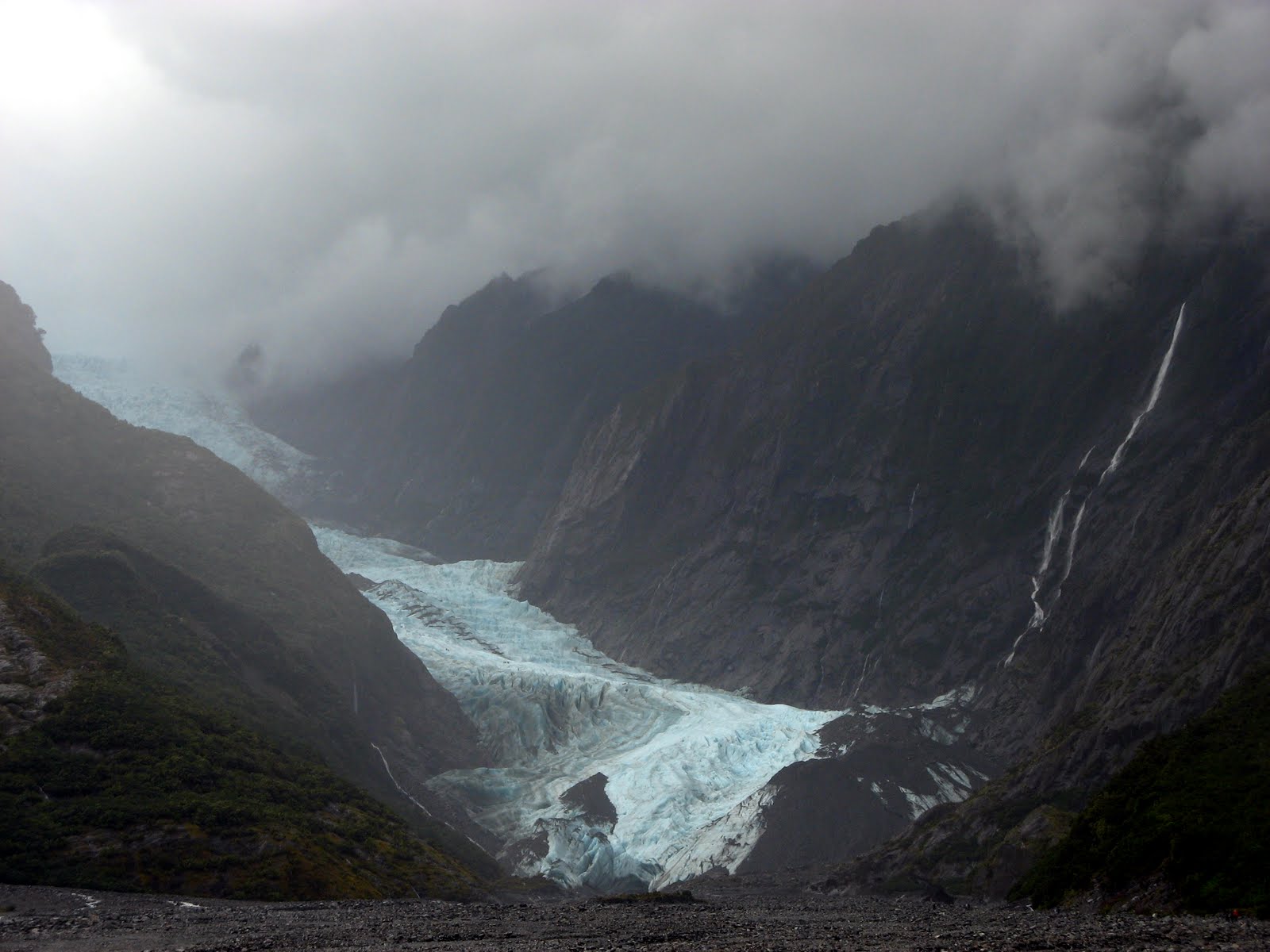
On our way down the west coast of the South Island, Dave and I stopped at the Franz Josef and Fox Glaciers.  Our hiking plans were completely thwarted by the torrential rains that had hit the area just a few days before our arrival.

That's a lot of water going under that bridge...

We did manage a quick walk up the glacial valley to the Franz Josef Glacier.

Waterfalls to rival Ithaca's cascade down the walls of the valley

Glaciers are rivers of ice...  literally.  Meters upon meters of snow will fall on the top of a steep mountain.  The weight of the constant snowfall compresses itself into sheets of ice.  The weight of the denser ice then slowly starts to slip down the mountain.  As the ice moves, it carves out grooves in the side of the mountain.  Viola!  A glacier and a glacial valley!

The massive Franz Josef glacier

Glaciers advance and retreat, meaning they move forward, away from their source (the “neve”), or backward, toward their source.  When the rate of glacier creation—snowfall in the neve—is greater than the rate that the glaciers are melting and breaking apart at their terminus, then the glacier advances.  Most glaciers around the world are retreating, but the glaciers on the west coast of the South Island are advancing.

water in three phases:  cloud, river, ice

The Franz Josef and Fox glaciers are unique because they travel from the highest mountains in the country—over 3,000 meters—to the coastal rainforest in a span of only a few kilometers.  Dave and I slept next to a beach, but we visited the Franz Josef glacier before lunch.  These glaciers also move much faster than the average glacier.  A heavy snowfall in the neve will produce an advancing glacier in about five years.  The glacier can move up to a meter a day.

the only picture in which one or both of us is not sticking out a tongue, crossing eyes, or making goblin faces

So, that's all you ever wanted to know about glaciers.  Another spectacular phenomenon of our beautiful world!

Monday, April 26, 2010

Moving South...

From Taranaki, we headed south to Wellington, the capital city of New Zealand.  I'm not much for big cities, and neither is Dave, so we spent only one day in Wellington.  Most of our time was spent at Te Papa Tongarewa, the National Museum.  It's one of the best museums I've ever visited.  I really enjoyed the exhibits on the geology and natural history of New Zealand.

Here are some pictures from our time in Wellington and Te Papa:


After Wellington, we took the Bluebridge ferry across the Cook Straight.  The voyage was very "meh," but the two ferry companies try to make it sound more exciting than it actually is.  It was pretty expensive to bring the van across, but since it's our transportation and our home, it was worth it.  Here are some pictures from the Cook Straight:

Sunday, April 25, 2010

Taranaki: This Makes 3 Mountains in 5 Days

Back in New Plymouth at the library.  Two days ago, after sitting right here, we went to the North Egmont Visitors' Center, packed our bags, parked the van, and hiked in to the Maketawa Hut.  The New Zealand Department of Conservation maintains hundreds of backcountry huts, which are very convenient for hikers and trampers.  This was my first night in a DOC hut with my brand new, shiny backcountry hut pass.

thumbs up!  DOC hut!

At first, I wasn't sure if we'd get to climb Taranaki, due to the clouds covering the mountain.  But when we woke up in the morning, the summit was clear, so we decided to give it a try.

whoa...  that shit is STEEP

First the track takes you up a steep road to an alpine club hut.  Then it climbs through a little gorge to a series of stairs.  From the stairs, you drop out onto the scoria slopes (steep slopes covered in gravel and sand).  Last, you climb a steep, old lava flow nicknamed "The Lizard" in a long scramble to the top.  At the top, you cross an ice- and snow-covered crater to get to the true summit.  Except we didn't stand on the true summit, as it has religious significance for the Maori.

above the clouds :-)

After getting my butt handed to me by Ruapeho, I was so happy that this day went well.  The climb is steep and strenuous, but it's definitely "do-able" by mere mortals, like myself.  The hike rises 1.6 km--one vertical mile--in about 5 km (~3 miles).  I've now climbed the three major peaks on the North Island in the span of five days.

Here are the rest of the pictures from the day:


We're going to head toward Wellington later today, then on to the South Island and all of the wonderful hiking and tramping there!  I've written a few posts to automatically post over the next week or two, but maybe we'll find another public library soon.  Until then...  onwards and upwards!

Friday, April 23, 2010

Tongariro II: Who Goes To Mordor Twice?

At the moment, Dave and I are in New Plymouth, a lovely little city on the Pacific Coast near Egmont National Park and Mt. Taranaki.  We jumped into the public library to use the internet.  Here's a recap of the past few days...

About a month ago, I took an “epic” trip to Tongariro National Park with my Earthwise Valley friends (read about it here, here, here, and here).  We climbed Ngauruhoe, the conical volcano (~2200 m) that was the inspiration for Mr. Doom in Peter Jackson's the Lord of the Rings movie trilogy, and part of the group climbed Ruapeho (~2700 m).  I didn't get to climb Ruapeho, and Dave didn't get to go on the trip at all, so Tongariro was the first stop on our New Zealand road trip.


Day 1, Tuesday, 4/20:  We had left Tuateawa late the previous day, so we woke up early and finished the drive to Tongariro.  After prepping our packs, we hit the trail around 11 a.m.  We took our time and enjoyed the great weather as we passed Taranaki Falls and then the Tama Lakes.


We got to the same basecamp where I had camped four weeks previous in the late afternoon.  There was plenty of time to scout out a flat tent site, sheltered from the wind, to set up the tent and sort gear, to dig a latrine hole, and to put together dinner fixins'.


The sunset wasn't as spectacular as the first sunset the last time I was there, but it was still very pretty.  Since we had arrived at the campsite so early, we were in the tent only an hour after dark (7:30 p.m.).  We stayed up talking until about 9:30 p.m, until we were able to doze off.  It was a cold and windy night.


Day 2, Wednesday, 4/21:  Summit day!

Sunday, April 18, 2010

Our Pimped Ride

This week, Dave and I were dog-sitting as we prepared for our six week road trip across the North and South Islands of New Zealand.  The dogs, Evee and Ninya, are New Zealand Huntaways.  They're two of the most awesome dogs I've ever encountered!

"you can't say no to me!"

Starting tomorrow morning, we will be living out of a van, so this week we took a few days to build an awesome platform bed into the back of the vehicle.


Under the bed, there is space for our clothes and personal items; hiking and camping gear; and a nearly-fully outfitted kitchen (cooler, propane range, and pantry box).

All pimped out and ready to ride!  But Evee and Ninya are wondering where we are going, and whether they will come along...

So, until June 1, my updates will be irregular.  I've written a few blog posts that will automatically post themselves over the course of the next few weeks, so I don't feel any obligation to find internet.  Although I will probably pop into a library or internet cafe to check email and post a few pictures a few times, I'm looking forward to an unplugged existence.

Until June...  onwards and upwards!

Friday, April 9, 2010

The Next Chapter

Today the other summer 2010 residents are catching a ferry out of Coromandel to Auckland.

summer 2010 residents at the gate of the valley
from left to right:  laura (nyc), hannah (yorkshire england), dave (upstate ny), nicole (upstate ny), john (georgia), bexie (minnesota via ecuador), daniela (mexico)

Two days before everyone left, we played a silly little series of games.  Two of the very creative residents came up with an obstacle course (incorporating activities we do frequently: hand sawing wood, mulching, eating watermelon, etc.), a scavenger hunt, egg toss, frisbee target shoot, and a blindfolded dizzy walk.  Hilarious and a lot of fun.


I can't believe that I've been in New Zealand for seven weeks--the time has gone by so quickly!  Overall, it's been a positive experience.  I've definitely learned some stuff...  stream of consciousness begins, Nico-style (with bullet points, haha!)...
  • kitchen stuff:

    • making non-loaf breads by hand (pita bread perfection, tortillas)
    • first time making a quiche
    • working with beets (they're so great; how did I not know about them?!)
    • working with eggplant (likewise!)
    • baking and cooking without a recipe (definitely not new) but with a general idea of what I want the end product to be (definitely new!)
  • construction:

    • design (especially the composting toilet project)
    • intermediate carpentry
    • first time doing any sort of masonry
    • earth/ mud construction (earth oven)
  • backpacking:

    • new backcountry recipes (i.e. vermicelli with dried tofu, seaweed, shitake, peas, and soup mix)
    • very lightweight entertainment (yahtzee and iPod--never used either in the backcountry before!)
    • more experience hiking on very unstable scree
  • philosophy:

    • general thoughts and specific details on how I want to live my life back home in Upstate New York
    • remembering why I left in the first place--to find out what's really important--making small steps in that direction
    • more observations about people, animals and the earth, and the general nature of things
may all of your storms end with rainbows :-)

Believe it or not, it took me a few weeks to get accustomed to not going to an office every day, not being constantly stressed out, not eating processed foods, not staying up late, not sleeping inside, and all of the other maybe-not-so-positive-but-not-bad-enough-to-kill-you things I used to do to myself.  I don't feel like I was totally awake over the past seven weeks.  Even though I haven't left yet, I'm really eager to come back to Tuateawa to realize my full potential here during June and beyond.

Dave and I are sticking around for another week while the program admin is out of town to watch the dogs. I never used to like dogs, but I really like Evie and Ninya, and I can't wait to play with them all week!


We'll be setting up the van to be our temporary home for the next five weeks.  Who knows where we'll end up during April and May!