Pages

Wednesday, November 25, 2015

How to Adjust the "Mountain Mama" Harness

This pregnancy, I used a borrowed "Mountain Mama" harness by Mad Rock, a.k.a. The Strangulator.  Learning how to fit it to my body required looots of trial and error.

Eventually, I figured out that I need two adjustment settings:  one for belaying and one for climbing.

Hopefully this beta will help some other pregnant climber out there.  :o)

Belaying
To belay comfortably, loosen the strap directly above your hip so the tie-in point is high and looser at your breastbone, with the red belay loops close together.  Also, don't belay (toprope) climbers that are significantly larger than you are, as this adjustment transfers more pressure to your mid-back, instead of around your legs.

This is the intuitive way to adjust the harness, but it compresses your rib cage and prevents you from raising your legs.  Result:  if climbing, you can't breathe while weighting the harness, and you can't keep your face/ belly off the rock while being lowered.

belaying adjustment
Climbing
To climb comfortably, cinch the straps directly above your hips down as far as reasonable.  This separates the tie-in points and pulls them low across your belly, but it also transfers more weight to the straps around your legs and lower back.  If I rest or fall, the tie-in point rises to the level of my sternum and doesn't crush the bump.

climbing adjustment
Around 36 weeks, the harness just got too uncomfortable, and I stopped toproping entirely and switched over to gentle bouldering traverses.

Sunday, July 5, 2015

Nova Scotia

While Dave was preparing to leave for a 2.5 week mountaineering trip in the Cascades, I decided that he wasn't allowed to have all of the fun - I would have a little adventure of my own.

Destination?  Halifax, Nova Scotia.

Why?  Cheapest flight out of Ithaca to somewhere interesting.

The general plan?  Rent a car, drive somewhere interesting, hike along the way, camp.  No specific itinerary or route, and therefore no reservations.

Of course, I couldn't make it too easy:  no smartphone or GPS for this trip.  I used maps printed on dead trees, questions to friendly passersby, and a healthy dose of serendipity to navigate and plan my next move.  How quaint, eh?


Here are the highlights...

From Halifax, I drove along the southern coast.  This part of the island felt abandoned and overlooked.  I camped at Sheet Harbor and enjoyed the solitude.

grounded
Next was Cape Breton Island, and specifically the Cabot Trail, a scenic drive at the northern tip of the island.  I'd read that the hiking was great and the scenery was superb...  but I thought the hiking was over-rated and the scenery was "just nice."

My favorite location was this little fishing harbor on the western coast that wasn't mentioned anywhere in the tourist brochures:  Pleasant Bay.  The easterly winds were so fierce that they were blowing the waves away from shore!

no waves here
I spent less time than I expected on Cape Breton Island and ended up in Pictou, the terminus of the Prince Edward Island ferry.  PEI was never part of the plan, but the ferry was right there, and free going over to PEI.  How could I resist?

Prince Edward Island was beautiful:  agricultural, quaint, rural, colorful.  I spent only one day, driving across the southern part of the island, stopping to see whatever caught my fancy.  A highlight of the trip, and completely unplanned!

point prim
life-changing clam chowder - now i understand!
growing potatoes
From PEI, I checked out Cape Chignecto and its hiking trails at the tip of the Bay of Fundy, home of the world's highest tides.  Once again, the hiking at Cape Chignecto was over-rated, and I stayed for much less time than I had expected.  (Side note:  Cape Chignecto has a 3-4 day coastal backpacking loop that looks very exciting and beautiful, but already my pack's hipbelt is uncomfortable, so that wasn't an option for me on this trip.)

Instead, I continued on to Five Islands and camped at the provincial park there, high on a bluff overlooking the Minas Basin.

not even low tide.  crazy.
I looped around the Bay of Fundy and ended up at another favorite place, Delaps Cove.  The camp steward recommended a silly little walk in the equivalent of a county park here in the States, and for whatever reason, it captured my fancy.  I think this highlights the value of wandering, being open to suggestions, and having no fear of adjusting your plan on the fly.

uh, where's the water?
I also enjoyed a cone of "Privateer's Bounty," vanilla ice cream with salted toffee and black licorice jelly.  That probably didn't hurt my opinion of the area.  :o)


I passed by Kejimkujik National Park and did a few more hikes.  This park is best enjoyed by canoeing or kayaking, but the parts I saw on foot reminded me of the Adirondacks.

"keji"
Along the southern shore, west of Halifax, I ran into Tourism Central.  The historical town of Lunenburg and the photogenic lighthouse of Peggy's Cove are mentioned in every tourist brochure, and while they are lovely, I passed by many more beautiful villages and lighthouses that were not swarming with people.

peggy's cove from afar - those black dots are people
Also, I can't believe I have written this much with only one photo of a lighthouse.  Seriously, the Nova Scotia coastline is covered with lighthouses.  Here, have another:

ridiculously cute, no?
This was my last solo trip for many years (the thumping in my lower abdomen makes it hard to forget), and that made it very special.  I intended a mostly hiking trip, and because the hikes were short, easy, and somewhat boring, it turned into a mostly road trip.  I'm happy I didn't have a plan and was able to discover places for myself.

Friday, May 29, 2015

46er!!! ...And the Next Adventure

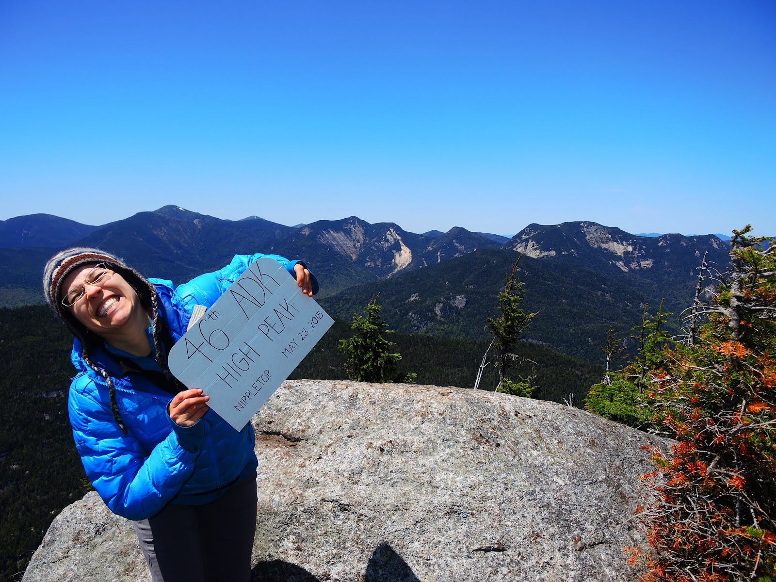
On Saturday, May 23, 2015, I hiked to the top of Nippletop and became an (unofficial) 46er.

However, this trip report begins at 11:00 a.m. on Monday, December 29, 2008. Bear with me: I have a story to tell. It's a tale of adventure, struggle, character - and yes, it's also an old fashioned love story.

So here I am, the baby face of 6.5 years ago: I'm standing in lightly drifting snow, figuring out how to put on my snowshoes, fresh out of their eBay box. I've got my Columbia jacket I've had since college, with its thin fleece lining and non-water-resistant shell, and a pair of my mother's old wool mittens from Sears. The cap is already partially frozen onto my waterbottle. I am drastically under-prepared and dramatically over-excited, because it's Day 1, Mile 1 of my second winter hike ever, and my first High Peak experience.

I'm hiking with two friends and the guy I started dating seriously just a month before. The trail goes straight up, and it takes us 3 hours to go 2 miles because we stop every 1/2 mile. It bitterly cold on the summit, and savage winds make mincemeat of my sad jacket. But just like that, I've hiked my first High Peak.

Cascade Mountain, 12/29/2008
Then my boyfriend reminds me that we're not turning around just yet - there's a second summit "over there." I realize that anyone who hikes 46 of these beasts must be certifiably insane, plus possess powers of stamina, balance, fortitude, and power that I would never have. I was frozen to my core, my knees ached, and the roar of the wind took my breath and left me fearful - and exhilarated. I was so small on that mountain, yes, but I also was something that mattered, someone who could remain standing while the wind roared.

Why did I return to those mountains? Stubbornness? Curiosity? Something to prove? Adrenaline rush? Fear of missing out? A budding love of the wilderness? I don't know, because my first experience was kind of miserable.

But I did return.

Sometimes with friends...

Rocky Peak Ridge, 2/23/2012
Sometimes alone...

Phelps Mountain, 3/3/2013
But usually with that boyfriend. That boyfriend, who took me up the Trap Dike, over Colden, then up the back side of Algonquin to traverse the MacIntyre Range on my first ever backpacking trip. (Let's just say that he was trying to kill me, and if I survived, I'd make a decent girlfriend.)

Algonquin, 8/16/2009
Some of his "adventures" were my misadventures, and especially in the early days, I didn't always love him when we were in the mountains. But as the miles passed under our feet, we learned to work as a team. My developing backcountry skills gave me confidence to voice my opinions and needs. He learned to give appropriate feedback and recognition. And eventually, there were no more misadventures.

We hitched our lives together on the summit of Mt. Marcy, highest point in New York State: a fitting place for our love, born in the wild.

Mt. Marcy, 6/15/2013
Without noticing, I had hiked 28 of the High Peaks and had become one of those certifiably insane hikers who can start a one match fire and who carries a toothbrush without a handle (saves 15 grams!). 28 down, 18 to go - and then I thought I might finish, because what the heck: I, and he, and we were having fun.

Finally: the morning of Saturday, May 23, 2015. Today I finish my 46. I'm hiking with some friends, and of course, my husband. As we gain altitude, I start to see the back side of the Great Range, Haystack there, Colvin and Blake in front - memories from so many miles of trail, each peak an old friend now. Speaking of old friends, those hiking partners from my first High Peak trip are married, with a baby son, and live across the street. It's a bluebird day - reminds me of my wedding day - in fact, there's Marcy.

After 6 years, 4 months, and 25 days, 275 miles, 117,000 feet of elevation gain, 18 distinct trips spanning 27 calendar days, 3 pairs of hiking boots, 50 pounds of trail mix, and an infinite number of black fly bites, I summited at 12:45 p.m.


After 46 of these, there isn't much to say. It was a lovely day, and this adventure was complete.

Of course, the completion of one adventure always marks the start of the next one...


P.S.  Completing the 46 on Nippletop was a total coincidence - but it does make me chuckle.